When we first started #RVing, we picked a destination and just started driving. More often than not, we’d end up cranky at the end of a too long day in the truck. Step by step RV trip planning made easy!
Planning a shakedown trip for the month of September, I looked for an easy planning tool that would allow us to drive 400 miles or less most days and enjoy the trip as much as the adventure. RVParky.com makes it easy to eyeball the distances between two points on a map, zoom in close to find a middle point and even shows camping possibilities – whether it’s a WalMart, rest stop, Cracker Barrel or campground. (Note, my experience is RVParky.com online, using the app doesn’t allow some functionality. Once on the road we prefer to use AllStays).
Our 4,000+ mile sojourn across 9 states in September 2016 will include Badlands National Park, Custer State Park, Wind Cave National Park & Theodore Roosevelt National Park as well as Glacier National Park and Rocky Mountain National Park. We’ll add 3 new nat’l parks to our list, bringing it to 18 (of 58 Nat’l Parks) as well as explore areas of Glacier and RMNP we’ve never seen. But first, back to the planning.
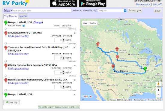
The 4 Major Destinations of our September Adventure
RVParky.com to the rescue. Of all the online resources, so far we like this one the best because it allows us to drop a pin on a map and see not only how many miles, but what camping possibilities are in the area and how many miles they are from the road we’re traveling. 🙂
RV Trip Planning Made Easy … a Tutorial on Using RVParky.com
1. Determine a rough idea of the major stops we want to make along the way. For this trip, David wanted to see Mt Rushmore, I wanted to explore Theodore Roosevelt National Park, both of us wanted to visit friends in Glacier National Park and our son in Denver (Rocky Mountain National Park). So I added pins in those 4 locations. To add a pin, click on the green plus sign: “Add a Stop” at the bottom of the Trip Planner tab.
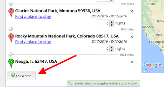
To add a pin, click “Add A Stop” and type in what you want – usually typing in a National or State Park works without using the city, sometimes you need to add the city.
If you look closely just after each segment on the left, RVParky.com tells me how many miles from one to the next. Yikes! 1040, 598, 946 & 1028 miles do NOT fit the relaxing travel guidelines of approximately 400 miles/day cross country!
2. I need to find stops along the way to break up the route. To do this, eyeball what should be about halfway or less and then click to zoom in on the map, close enough to see towns along the route. Then I type in a likely town name in the “Add A Stop” box.
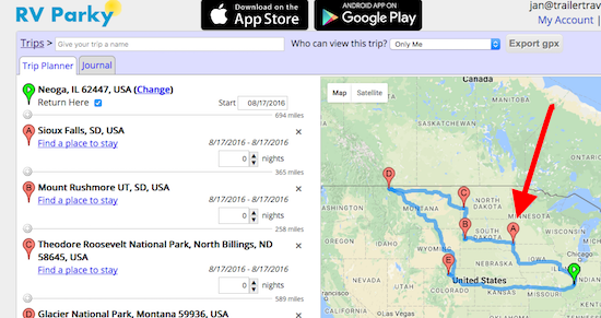
Found Sioux Falls on the map
3. Type Sioux Falls in the Add a Stop box and then click GO.
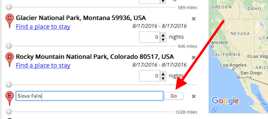
4. But then Sioux Falls won’t be in the right order, so you click and drag on the “E” pin to drag it up just after the start point of Neoga.
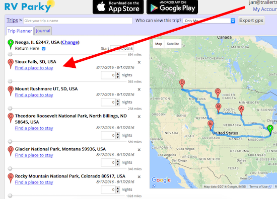
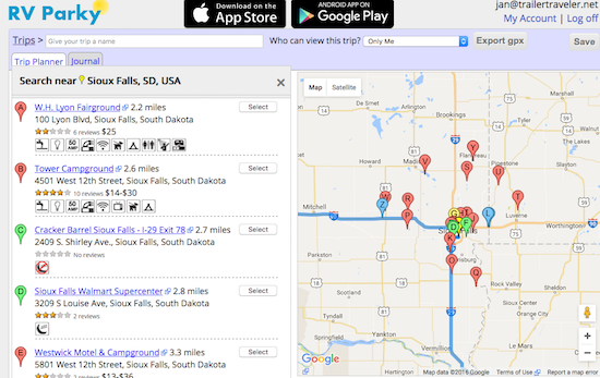
5. After dragging it into the correct order, it’s time to locate a potential place to stay for the night. Click “Find a place to stay” beneath the Sioux Falls location. Here’s what you see, not only a list of possibilities, but also plotted on the close up map so you can choose what’s best for you!
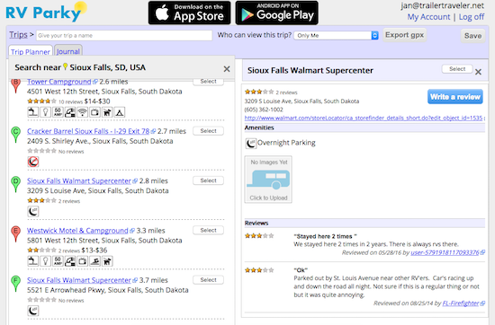
6. Clicking on each individual possibility brings up a screen with more information as well as reviews! This example is WalMart, it also gives the telephone number. I always call and make sure it’s OK to stay overnight and ask where they’d prefer we park.
7. Back to the planning … if you notice on the original plan, there were several legs longer than we’d like, so now it’s time to go back and adjust accordingly.
And that’s RVParky.com planning in 7 easy steps! Do you have a trip planning tool that allows you to easily see how far it is between points to plan less than 400 mile driving days? Please leave a comment and share! Cheers! Jan

